Anna J. McGraw
I completed my B.A. in Anthropology with a concentration in Biological Archaeology at Hamline University in May of 2012. After graduation I worked as an Archaeological Technician and Field Director. During this time, I waded through swamps, and fields of poison ivy and briar in efforts to locate archaeological sites. I mapped these sites on a Trimble GPS and then later mapped them all by hand. After doing this for a couple of years, I realized that interpreting maps and making new ones was the part of the job I enjoyed the most.
This realization led me into looking at the MGIS program at the University of Minnesota. I ended up going in 2017 and graduated in May of 2019. GIS ended up being the perfect combination of all of my interests, technology, the environment and lastly maps. During my time at the University of Minnesota I tried to explore as many different aspects of GIS as possible. I took classes in programming, cartography, databases and remote sensing. I learned Python, SQL, how to use ArcMap, and most importantly, how to be resourceful and learn something I did not know.
In the future I hope to expand my programming skills in Python, SQL, JavaScript and become a GIS Developer, a career where I could continue to push myself and learn new things every day. I am also interested in data science, data analysis and database management.
In my free time, I love to road bike, my goal for the summer is to have the fastest time across the Stone Arch Bridge on Strava, cross-country ski, I’ll be doing my third Kortelopet this winter, and read, last year I read 39 books.
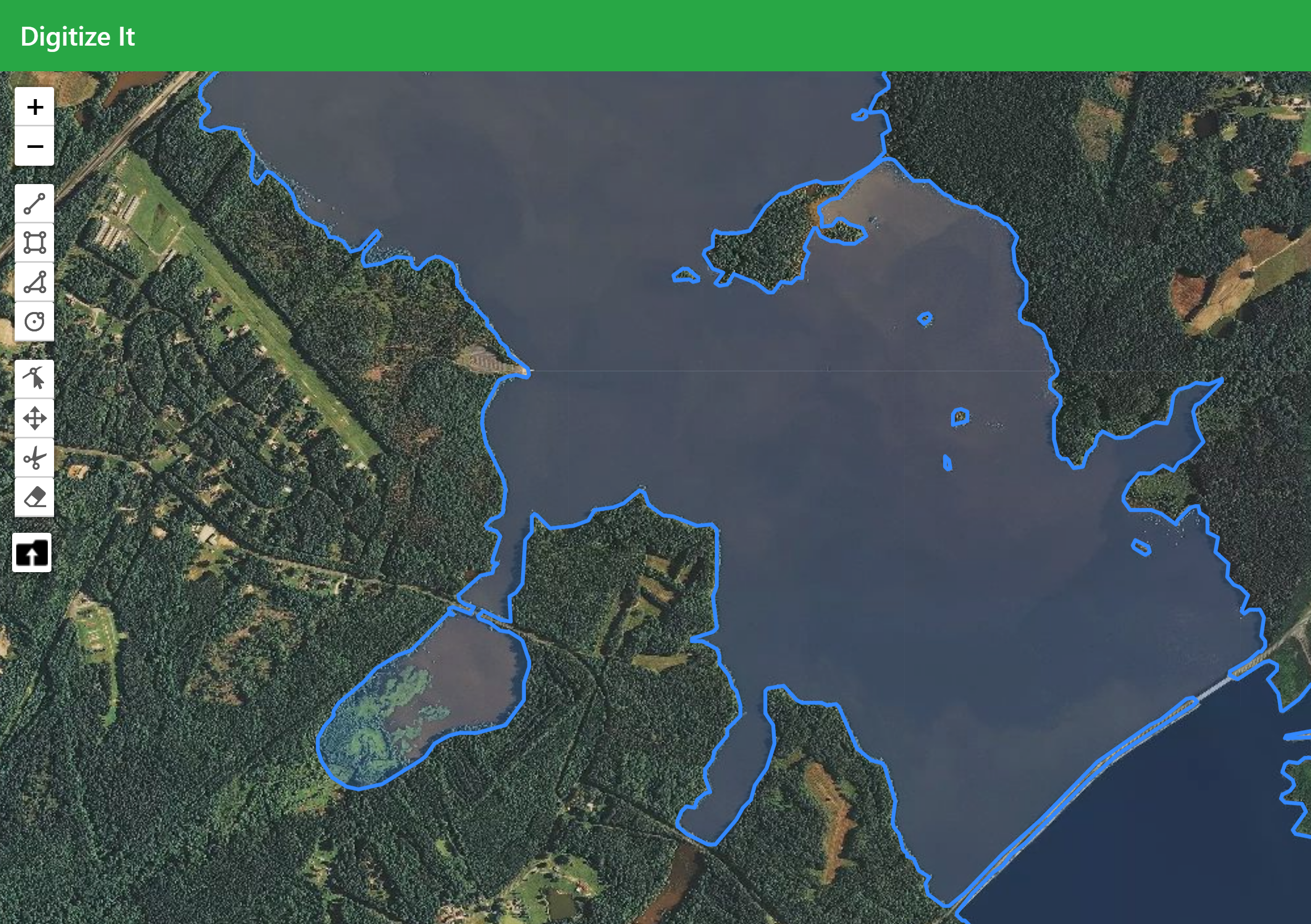
This project is an online shapefile editor, click on the picture to follow the link.
I made this website as a way to learn JavaScript, NodeJS, and to use different mapping API’s. For this project I had to modify a script to convert Shapefiles into GeoJsons. I learned how to use multiple Mapping API’s such as Leaflet and Google, as well as exposing myself for the first time to Bootstrap, MongoDB, Express.js and Angular.js.
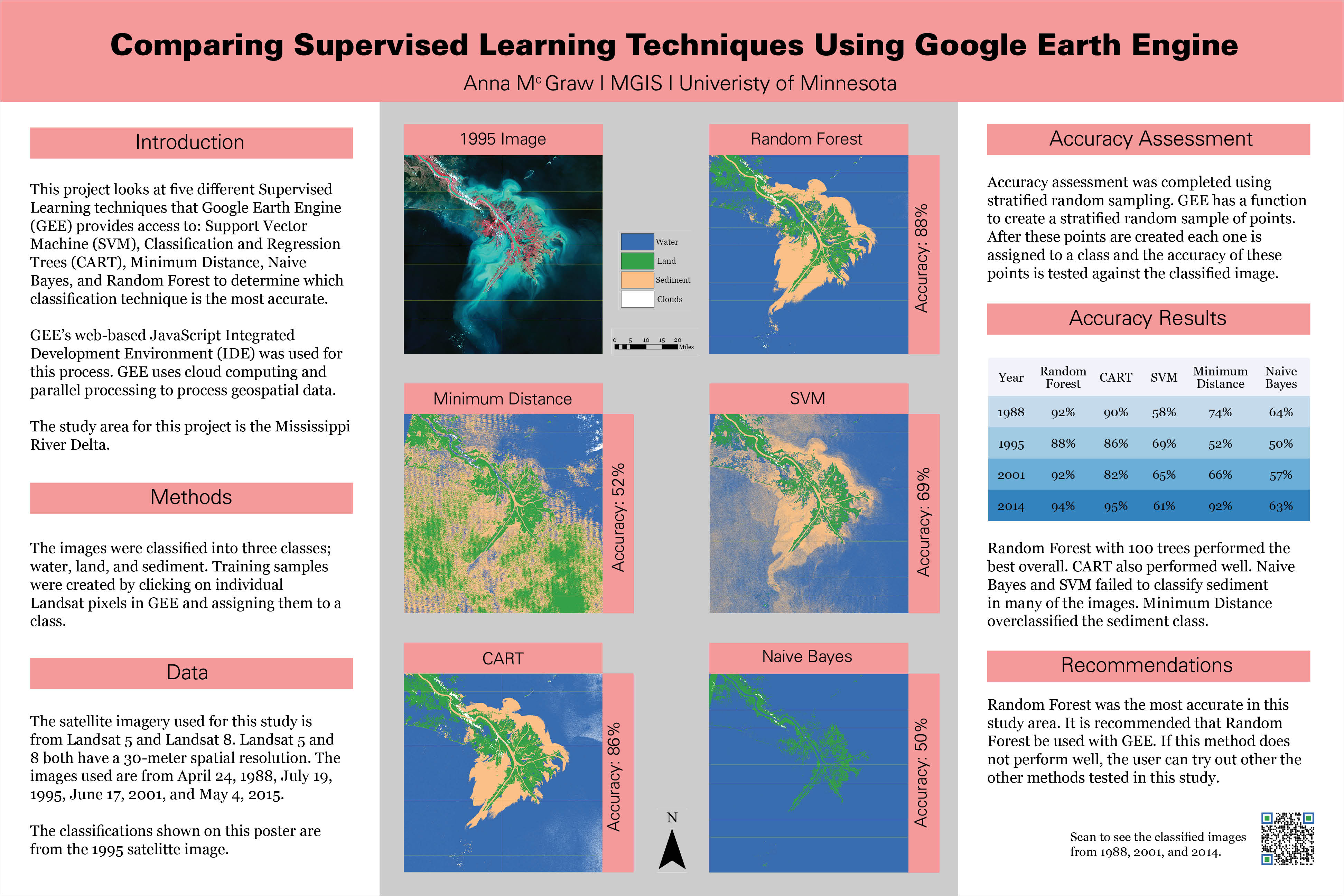
For this project I compared five different supervised learning techniques: Support Vector Machines, Classification and Regression Trees (CART), Minimum Distance, and Naives Bayes.
I wrote the code for this using Google Earth Engine’s web-based JavaScript Intregrated Development Environment(IDE). I also translated the code into python and put it in an interactive Jupyter Notebook so that any image for the Mississippi Delta can be classified.
Click here to see the code on Google Earth Engine.
Click on the image to see all the different years classified.
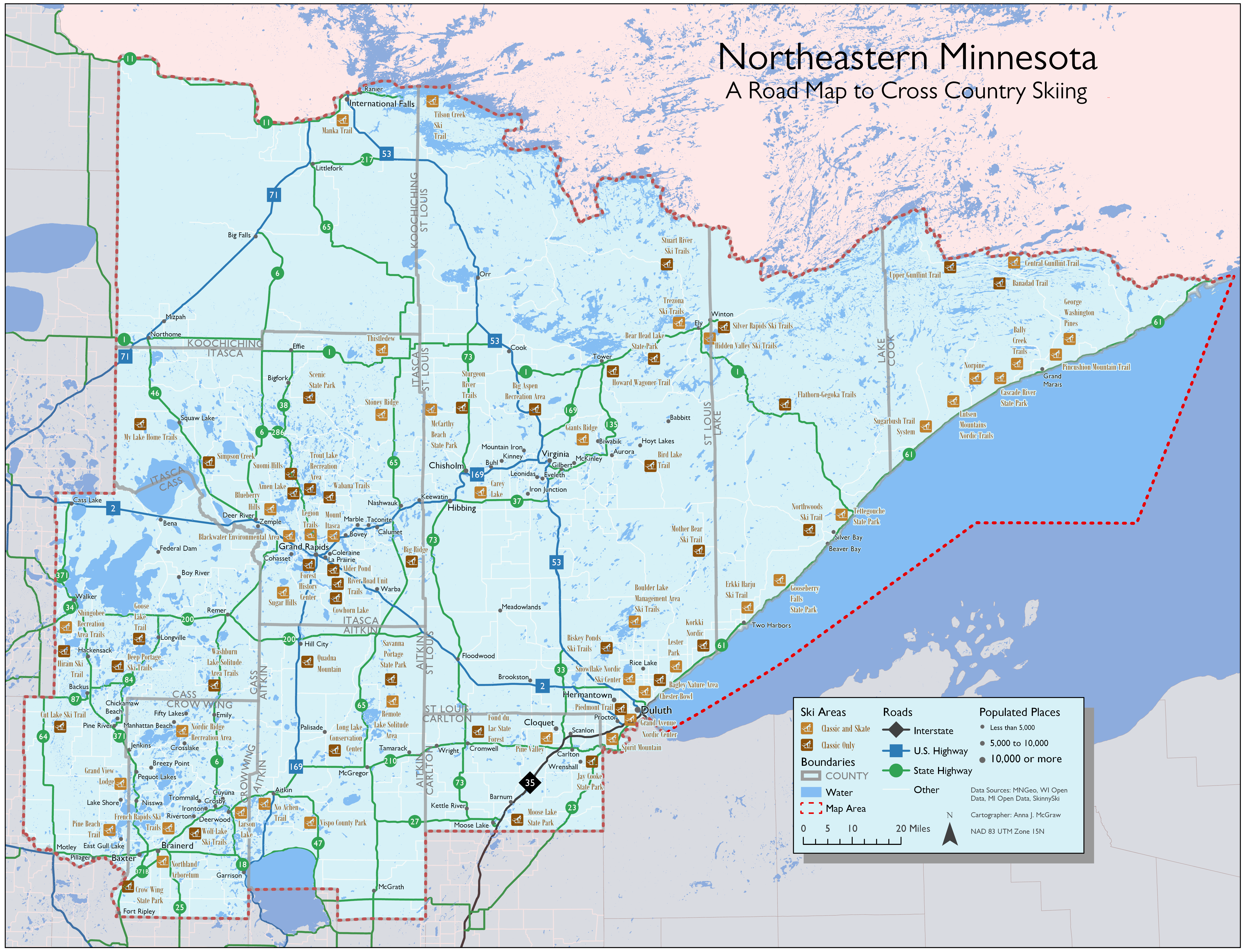
For a class during the MGIS program, we were asked to make a road map of Northeastern Minnesota. We could make a regular road map or choose any theme we wanted. Since I had just completed a cross-country ski race, the Kortelopet in Hayward, WI, and spent much of my winter checking ski reports on SkinnySki.com, I decided to make a cross country ski themed map.
For this map I used colors normally present in a downhill ski map, red transparent for off limits (the area this map doesn’t cover), green circles for Beginner (State Highway), blue squares for Intermediate (U.S. Highways) and black diamonds for Advanced (Interstates).
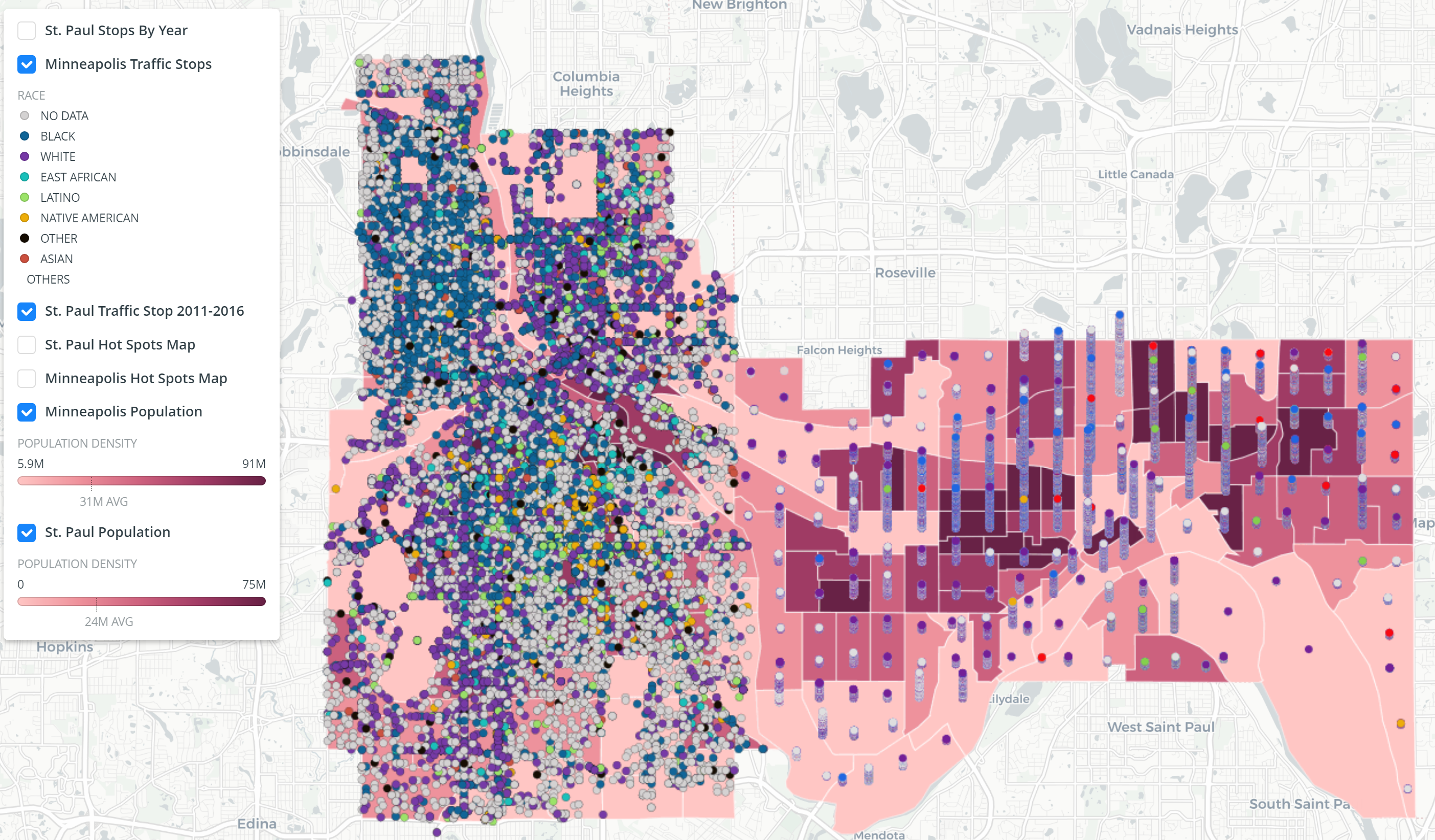
This web map was made from Saint Paul’s and Minneapolis’s open data portal and was made on CartoDB. Using the map, you can see traffic stops and population of different races in each census block group of Minneapolis and Saint Paul.
This was completed for a group project where my primary responsibility was to visualize the Saint Paul traffic stop data. I ended up following and modifying the SQL on this page to stack the traffic stops on top of each other.
Click on the image to visit the web map.
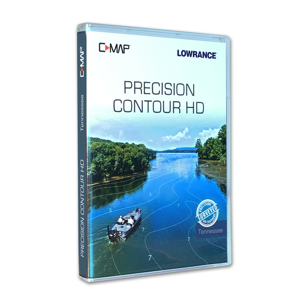
This is a project I have worked on for over a year with C-MAP and Navico. This is software for a Lowrance Depth Finder for 14 lake maps in the state of Tennessee. There is another for the state of Alabama and I am currently working on a project for North Carolina.
For this project, I reviewed all the sonar data that came in from a group of surveyors and verified the depths. I also came up with creative solutions to solve problems along the way.